|
 Another
brilliant sunny day with temperatures forecast to soar into the
high twenties. We chose a local route with plenty of shade and
drove to the top of Wass Bank, map ref. SE 561806. We set off
at about 9.30am down the road for about 200m and turned left on
to a farm road. Near the junction was a large bed of wild raspberries
with the last of the fruit just waiting to be picked, so we had
to oblige. After a few minutes of sheer indulgence we continued
on our way for 300m to Long Grain, a large modern style house by the track.
Opposite the house the path crosses a field and enters the woods
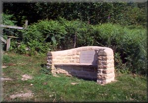
above High Woods Farm. Where the path emerges from the woods there
is a very substantial stone memorial seat with a lovely view down
the valley called Another
brilliant sunny day with temperatures forecast to soar into the
high twenties. We chose a local route with plenty of shade and
drove to the top of Wass Bank, map ref. SE 561806. We set off
at about 9.30am down the road for about 200m and turned left on
to a farm road. Near the junction was a large bed of wild raspberries
with the last of the fruit just waiting to be picked, so we had
to oblige. After a few minutes of sheer indulgence we continued
on our way for 300m to Long Grain, a large modern style house by the track.
Opposite the house the path crosses a field and enters the woods
above High Woods Farm. Where the path emerges from the woods there
is a very substantial stone memorial seat with a lovely view down
the valley called 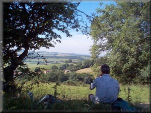 Shallow
Dale. We followed the path on to the access road to High Woods
Farm and up the valley for 200m to cross the beck and turn back
contouring round the valley side to join Westwood Lane and drop
down to the edge of Ampleforth at map ref. SE 576788. We walked
along the village street for a few hundred metres past the White
Horse Inn (good atmosphere and good food) to map ref. SE 582787.
Here we turned left up a very narrow tarmac road between the houses.
The road led up the hill through some imposing iron gates. Near
to top of the hill we climbed over a stile where two paths cross
and there was a convenient tree casting some pleasant shade over
a small bank where we sat for our early lunch with a lovely view
over Ampleforth to the hills around Yearsley, where I lived for
a few years some time ago. After our break we continued up the
hill to the end of a green road at map ref. SE 582795. We turned Shallow
Dale. We followed the path on to the access road to High Woods
Farm and up the valley for 200m to cross the beck and turn back
contouring round the valley side to join Westwood Lane and drop
down to the edge of Ampleforth at map ref. SE 576788. We walked
along the village street for a few hundred metres past the White
Horse Inn (good atmosphere and good food) to map ref. SE 582787.
Here we turned left up a very narrow tarmac road between the houses.
The road led up the hill through some imposing iron gates. Near
to top of the hill we climbed over a stile where two paths cross
and there was a convenient tree casting some pleasant shade over
a small bank where we sat for our early lunch with a lovely view
over Ampleforth to the hills around Yearsley, where I lived for
a few years some time ago. After our break we continued up the
hill to the end of a green road at map ref. SE 582795. We turned
 right
on to the green road and followed it out on to a minor road near
Windmill Farm, the site of an internationally renown sheet music
library. We continued on the minor road to Beacon House, about
500m, and turned left over the stile on to a footpath heading
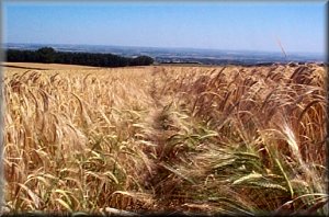
across the fields of barley and potatoes and along the edge of
the woodland for about 2km. At the end of the woodland the path
crosses a farm track and one more field, pasture this time, to
emerge on to Hag Lane about 400m from the village of Sproxton.
We turned away from Sproxton to walk along Hag Lane to Holly Bower
Farm. Part way along the lane we stopped under the shade of a
large ash tree for another break and lots of water. On a really
hot day I find there is nothing as good a right
on to the green road and followed it out on to a minor road near
Windmill Farm, the site of an internationally renown sheet music
library. We continued on the minor road to Beacon House, about
500m, and turned left over the stile on to a footpath heading
across the fields of barley and potatoes and along the edge of
the woodland for about 2km. At the end of the woodland the path
crosses a farm track and one more field, pasture this time, to
emerge on to Hag Lane about 400m from the village of Sproxton.
We turned away from Sproxton to walk along Hag Lane to Holly Bower
Farm. Part way along the lane we stopped under the shade of a
large ash tree for another break and lots of water. On a really
hot day I find there is nothing as good a 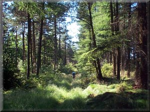 plain
old water to quench your thirst. We continued passed Holly Bower
farm to the woods and at map ref. SE 589807 we turned right on
a stoney forest track for 200m to map ref. SE 590809. Here we
turned left on to a forest track heading for a minor road near
Studford Farm. About 100m before the road the track turns right
and then left to come out on the road oposite Studforth Farm drive.
We turned on to the road and followed the road for about 2km back
to our starting point. You can get off the road and make your
way along the forest tacks but this route is a bit up and down
and frankly it was just too hot to be bothered walking any further!
The whole route was about 15km and took us about 5 hours including
our stops. plain
old water to quench your thirst. We continued passed Holly Bower
farm to the woods and at map ref. SE 589807 we turned right on
a stoney forest track for 200m to map ref. SE 590809. Here we
turned left on to a forest track heading for a minor road near
Studford Farm. About 100m before the road the track turns right
and then left to come out on the road oposite Studforth Farm drive.
We turned on to the road and followed the road for about 2km back
to our starting point. You can get off the road and make your
way along the forest tacks but this route is a bit up and down
and frankly it was just too hot to be bothered walking any further!
The whole route was about 15km and took us about 5 hours including
our stops.
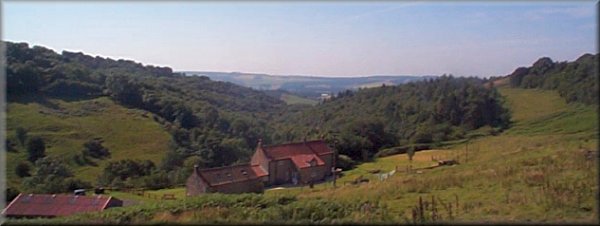
Looking
over High Woods Farm down Shallow Dale towards Ampleforth
|
|
|
|
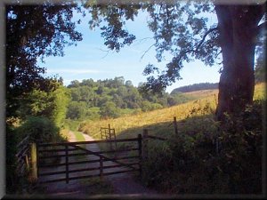
Farm
track in Shallow Dale
|
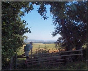
Path
beside Oxclose Wood
heading towards Sproxton
|
|