

The church at Kirby Underdale, Yorkshire Wolds
Menu:
National Parks
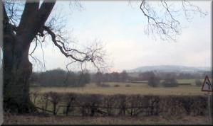 A group of ten of us met this morning at about
10.30 at map ref. SE 786585 a kilometre out of Bugthorpe on the
road to Kirby Underdale on the edge of the Yorkshire Wolds.The
grass verge is wide enough here to park off the road. The weather
was grey and overcast but it managed to stay fine and there were
even occasional bits of blue sky. We set off along the road towards
Kirby Underdale and after about 1km. we took the path across the
fields on the righthand side of the road into Kirby Underdale
village just over 1km away. In the village we stopped at the post
office/shop to get a bottle of water (forgot to bring one from
home!!) and continued along the road to the church. I think the
A group of ten of us met this morning at about
10.30 at map ref. SE 786585 a kilometre out of Bugthorpe on the
road to Kirby Underdale on the edge of the Yorkshire Wolds.The
grass verge is wide enough here to park off the road. The weather
was grey and overcast but it managed to stay fine and there were
even occasional bits of blue sky. We set off along the road towards
Kirby Underdale and after about 1km. we took the path across the
fields on the righthand side of the road into Kirby Underdale
village just over 1km away. In the village we stopped at the post
office/shop to get a bottle of water (forgot to bring one from
home!!) and continued along the road to the church. I think the
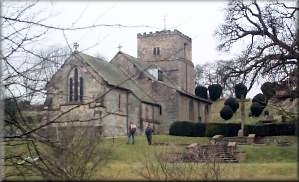 tower
of the church is Saxon - it has an interesting semi-circular arched
doorway at one end. We followed the path through the church yard
and across the fields to Manor Farm at Uncleby. Here we turned
down the road for about 150m and took the path to the right passing
below Woodley Farm where the ewes had just started lambing.The
theme for today's walk has to be spring what with new born lambs,
snowdrops, yellow aconites, and hazel catkins. The path took us
west below Mount Pleasant Farm and out on to an unfenced lane.
We walked up the lane for almost 100m and turned left onto a path
across the fields to Lower Sleights Farm. Here we walked up the
drive to the imposing gateway with its lifesize dog statues on
top of each gatepost. At the gate the path goes round the side
of the buildings along a
tower
of the church is Saxon - it has an interesting semi-circular arched
doorway at one end. We followed the path through the church yard
and across the fields to Manor Farm at Uncleby. Here we turned
down the road for about 150m and took the path to the right passing
below Woodley Farm where the ewes had just started lambing.The
theme for today's walk has to be spring what with new born lambs,
snowdrops, yellow aconites, and hazel catkins. The path took us
west below Mount Pleasant Farm and out on to an unfenced lane.
We walked up the lane for almost 100m and turned left onto a path
across the fields to Lower Sleights Farm. Here we walked up the
drive to the imposing gateway with its lifesize dog statues on
top of each gatepost. At the gate the path goes round the side
of the buildings along a 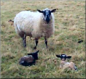 bridleway
which unfortunately is well used by riders and is very difficult
to walk amongst the mass of waterfilled muddy hoof prints. We
followed the muddy track south for about 0.75km. and then took
the path west for about 1.5km to the road. Where the path joins
the road the signpost has a marker proclaiming "The Chalklands
Way" - Ramblers Association, but I have been unable to find any
mention of it on their web site. We walked along the road towards
Bugthorpe for about 800m to map ref. SE 768582 where we turned
right onto a path along the edge of a field for 300m where we
turned left to cross three fields to the road. We walked 200m
along the road away from Bugthorpe and turned left onto a path
which we followed for 1km passed Keldsike Plantation to the A166.
We crossed the main road and followed the footpaths around the
field edges in a loop to avoid walking along the main road to
map ref. SE 779565. We crossed back over the A166 and walked up
Barr Lane back towards Bugthorpe. After 800m we turned off the
road to follow the footpaths over the fields to primrose Hill
Farm next to Longbowers Plantation. The dog there runs loose and
sounds quite fierce but seems to be well trained and knows his
boundaries. We walked down the farm road back to our starting
point on the Bugthorpe to Kirby Underdale road. The whole route
was about 16km. and took us four and a half hours including a couple
of stops. It proved quite a tiring walk in the slippy muddy conditions.
This sort of farm land is not the kind of country I really like
to walk in, so next week I'll try to head back up the dales if
the weather forecast is OK.
bridleway
which unfortunately is well used by riders and is very difficult
to walk amongst the mass of waterfilled muddy hoof prints. We
followed the muddy track south for about 0.75km. and then took
the path west for about 1.5km to the road. Where the path joins
the road the signpost has a marker proclaiming "The Chalklands
Way" - Ramblers Association, but I have been unable to find any
mention of it on their web site. We walked along the road towards
Bugthorpe for about 800m to map ref. SE 768582 where we turned
right onto a path along the edge of a field for 300m where we
turned left to cross three fields to the road. We walked 200m
along the road away from Bugthorpe and turned left onto a path
which we followed for 1km passed Keldsike Plantation to the A166.
We crossed the main road and followed the footpaths around the
field edges in a loop to avoid walking along the main road to
map ref. SE 779565. We crossed back over the A166 and walked up
Barr Lane back towards Bugthorpe. After 800m we turned off the
road to follow the footpaths over the fields to primrose Hill
Farm next to Longbowers Plantation. The dog there runs loose and
sounds quite fierce but seems to be well trained and knows his
boundaries. We walked down the farm road back to our starting
point on the Bugthorpe to Kirby Underdale road. The whole route
was about 16km. and took us four and a half hours including a couple
of stops. It proved quite a tiring walk in the slippy muddy conditions.
This sort of farm land is not the kind of country I really like
to walk in, so next week I'll try to head back up the dales if
the weather forecast is OK.
|
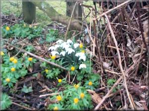
Snowdrops and yellow aconites beside the road near Uncleby
|
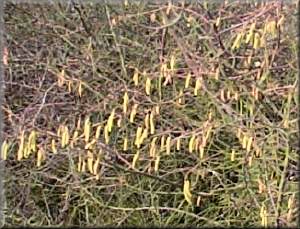
Hazel catkins
|
|
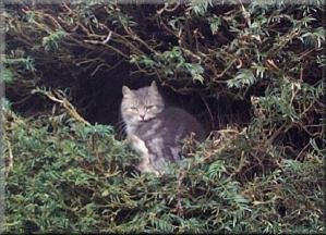
Cat resting in the yew hedge at Kirby Underdale church
|
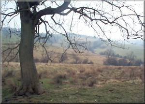
View into Ray Dale from our lunch stop above Opendale Beck
|