| 2001 walks | 2002
walks | 2003 walks | 2004
walks |
| 2005 walks | 2006
walks | 2007 walks | 2008
walks |
| 2009 walks | 2010
walks | 2011 walks | 2012 walks |
| 2013 walks | 2014 walks | 2015 walks | 2016 walks |
| 2017 walks | 2018 walks | 2019 walks |2020 walks |
| 2021 walks | 1993-2000 library | Find a Route Index |
| A few Routes to print out | Request a Route... |
Route No 55 - 17 Aug 2002
Baysdale, Hob Hole circuit - 15 km
North York Moors . . .
Route map from OS Open Space service
Map: OS Explorer OL26 North York Moors Western area. 1:25000
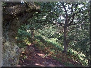
 A group of
5 of us met above Baysdale at map ref. NZ 654064 where there is
a little area to park 3 or 4 cars off the road. We set off at
around 10.45am to walk a couple of hundred metres back up the
road to pick up a bridleway to our left heading west over the
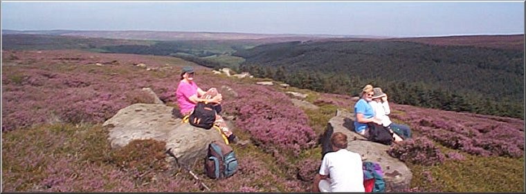
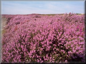
heather moor. The heather is the reason for our choice of route
to-day. The early bell heather is almost finished now but the
ling heather which covers most of the moor is at its best and
the entire hillside is just a carpet of purple. The weather was
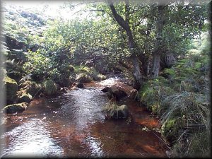
hot and humid and after walking about 2 km we reached the pretty
crossing of Great Hograh Beck where we stopped for a drink before
climbing up the moor on the other side of the beck.
A group of
5 of us met above Baysdale at map ref. NZ 654064 where there is
a little area to park 3 or 4 cars off the road. We set off at
around 10.45am to walk a couple of hundred metres back up the
road to pick up a bridleway to our left heading west over the
heather moor. The heather is the reason for our choice of route
to-day. The early bell heather is almost finished now but the
ling heather which covers most of the moor is at its best and
the entire hillside is just a carpet of purple. The weather was
hot and humid and after walking about 2 km we reached the pretty
crossing of Great Hograh Beck where we stopped for a drink before
climbing up the moor on the other side of the beck. 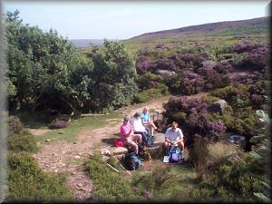 After
about 0.5 km from the beck the bridleway continues straight on
but we kept left on a well walked path (not marked on the map)
which turns south to join a moorland track which in turn is joined
(at map ref NZ 629058) by a bridleway coming up from Baysdale
Abbey. We followed the track south for 2.5km to the head of the
valley and then back north on the other side of the valley until
the bridleway led us down the end of the hill to Baysdale Abbey
- not an abbey any longer but a large well kept farm.
After
about 0.5 km from the beck the bridleway continues straight on
but we kept left on a well walked path (not marked on the map)
which turns south to join a moorland track which in turn is joined
(at map ref NZ 629058) by a bridleway coming up from Baysdale
Abbey. We followed the track south for 2.5km to the head of the
valley and then back north on the other side of the valley until
the bridleway led us down the end of the hill to Baysdale Abbey
- not an abbey any longer but a large well kept farm.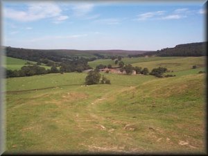 We continued
through the yard at the side of the farm on to the farm road beside
Baysdale Beck. We
followed the track for about a kilometre to map ref. NZ 627074
where we turned left to follow the sign posted route straight
up the hillside to map ref. NZ 627077. From here the path follows
the top side of the wall to join a bridleway at map ref. NZ 632078.We
continued on the bridleway along the valley side for 1.5km and
then cut down the hillside through the bilberries for about 200metres
to join the path on the bank of Baysdale Beck which we followed
to the Hob Hole picnic area. The stream was full of paddling children
and the grass was dotted with family picnics - a very happy scene
on this hot summers day. From Hob Hole we walked along the road
for a kilometre back to our starting point. the whole route was
about 13km and took us four and a half hours including several
drinks stops on this very hot day. We stopped at the Lion Inn
on Blakey Ridge on the way home for a long cool drink.
We continued
through the yard at the side of the farm on to the farm road beside
Baysdale Beck. We
followed the track for about a kilometre to map ref. NZ 627074
where we turned left to follow the sign posted route straight
up the hillside to map ref. NZ 627077. From here the path follows
the top side of the wall to join a bridleway at map ref. NZ 632078.We
continued on the bridleway along the valley side for 1.5km and
then cut down the hillside through the bilberries for about 200metres
to join the path on the bank of Baysdale Beck which we followed
to the Hob Hole picnic area. The stream was full of paddling children
and the grass was dotted with family picnics - a very happy scene
on this hot summers day. From Hob Hole we walked along the road
for a kilometre back to our starting point. the whole route was
about 13km and took us four and a half hours including several
drinks stops on this very hot day. We stopped at the Lion Inn
on Blakey Ridge on the way home for a long cool drink.