Route No 47a - Saturday 6 April 2002
Simonside Hills circuit - 11km
Rothbury,
Northumberland . . .
Route map from Ordnance Survey Open Space service.
Map: OS Explorer OL42 Kielder Water Bellingham & Simonside Hills 1:25000
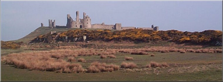
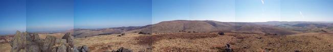
 We arrived in Rothbury where we had booked a holiday
cottage at lunch time on Saturday and after a snack in
a cafe on the main street we headed for the Simonside Hills just
outside the town. We parked at map ref. NY 053988 and climbed
the hill opposite the car park onto the permissive path around
the rocky escarpment.
We arrived in Rothbury where we had booked a holiday
cottage at lunch time on Saturday and after a snack in
a cafe on the main street we headed for the Simonside Hills just
outside the town. We parked at map ref. NY 053988 and climbed
the hill opposite the car park onto the permissive path around
the rocky escarpment.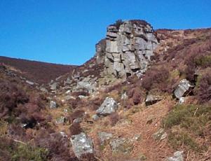 The weather was perfect, clear and bright with a cool breeze,
giving us a lovely view across Coquetdale. We followed the permissive
path for 3km to the end of the hill and made the steep descent
to Bob Pyle's Struddie. From there we followed the footpath south
skirting the edge of the forestry for 2.5km and turned east for
500m to Coquet Cairn. From there we headed north east on a footpath
for 3.5km back to the car park. It had been a very pleasant introduction
to walking in Northumberland and we were back just in time to
drive into Rothbury to collect the keys for our cottage, settle
in and find a good pub for an evening meal.
The weather was perfect, clear and bright with a cool breeze,
giving us a lovely view across Coquetdale. We followed the permissive
path for 3km to the end of the hill and made the steep descent
to Bob Pyle's Struddie. From there we followed the footpath south
skirting the edge of the forestry for 2.5km and turned east for
500m to Coquet Cairn. From there we headed north east on a footpath
for 3.5km back to the car park. It had been a very pleasant introduction
to walking in Northumberland and we were back just in time to
drive into Rothbury to collect the keys for our cottage, settle
in and find a good pub for an evening meal.
(top)
Route No. 47b - Sunday 7 April 2002
Kirk Yetholm, Pennine Way, The Schil circuit - 13km
Cheviot Hills, Northumberland . . .
Route map from Ordnance Survey Open Space service.
Map: OS Explorer OL16 The Cheviot Hills. 1:25000
 The
next day, Sunday, the weather was just as good with brilliant
blue clear skies and a nice cool breeze for walking. We drove
to Kirk Yetholm, the northern end of the Pennine Way. About 1.5km
out of the village along the Pennine Way route is a parking area
off the road at map ref. NT 840277 From here we climbed the Pennine
Way route onto the ridge where the path follows the Scotland/England
border. We continued heading south along the Pennine Way for about
6.5km from the car park to The Schil, a 601m peak with a wonderful
360 degree panorama of the Cheviot hills from the top. We had
our lunch at the top and fell asleep in the warm grass beside
the summit cairn. We returned to the car via the alternative low
level Pennine Way route. We had walked about 13km and it had taken
us almost five hours including a nap on the Schil. Now back to
Rothbury for another good meal in the pub. The
next day, Sunday, the weather was just as good with brilliant
blue clear skies and a nice cool breeze for walking. We drove
to Kirk Yetholm, the northern end of the Pennine Way. About 1.5km
out of the village along the Pennine Way route is a parking area
off the road at map ref. NT 840277 From here we climbed the Pennine
Way route onto the ridge where the path follows the Scotland/England
border. We continued heading south along the Pennine Way for about
6.5km from the car park to The Schil, a 601m peak with a wonderful
360 degree panorama of the Cheviot hills from the top. We had
our lunch at the top and fell asleep in the warm grass beside
the summit cairn. We returned to the car via the alternative low
level Pennine Way route. We had walked about 13km and it had taken
us almost five hours including a nap on the Schil. Now back to
Rothbury for another good meal in the pub.
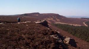
The Cheviot seen from the Schil
(top)
Route No. 47c - Monday 8 April 2002
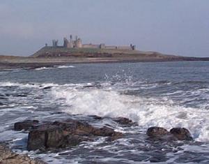
Coastal path from Craster, Dunstanbrugh Castle,
Low Newton,
Benthall and return - 18km
Northumberland Coast . . .
Route map from Ordnance Survey Open Space service.
Map: Explorer 340 Holy Island & Bamburgh 1:25000
 On
Monday we headed for the coast and parked in the fishing
village of Craster. We walked up the coast past Dunstanbrugh Castle
and then along the beach to Low Newton-by-the-sea. From there
the path cuts across the headland behind the dunes. About 3km
from Low Newton we crossed a footbridge over quite a deep watercourse
and then walked along the beach into Benthall, the little harbour
settlement just south of Beadnell. We had a look at the old lime
kilns on the harbour and then found a sheltered spot in the dunes
for our lunch. It was another fine day but the cool wind was quite
strong on the open beach. After lunch we returned the way we had
come to Craster. It had been a very pleasant day beside the sea.
The whole route was about 18km and took us about 6 hours including
a short stop at the pub in Low Newton on the way back. On
Monday we headed for the coast and parked in the fishing
village of Craster. We walked up the coast past Dunstanbrugh Castle
and then along the beach to Low Newton-by-the-sea. From there
the path cuts across the headland behind the dunes. About 3km
from Low Newton we crossed a footbridge over quite a deep watercourse
and then walked along the beach into Benthall, the little harbour
settlement just south of Beadnell. We had a look at the old lime
kilns on the harbour and then found a sheltered spot in the dunes
for our lunch. It was another fine day but the cool wind was quite
strong on the open beach. After lunch we returned the way we had
come to Craster. It had been a very pleasant day beside the sea.
The whole route was about 18km and took us about 6 hours including
a short stop at the pub in Low Newton on the way back.
(top)
Route No. 47d - Tuesday 9 April 2002
Wedder Leap, Border Ridge, Windy Gyle - 16km
Upper Coquet Dale, Cheviot Hills,
Northumberland . . .
Route map from Ordnance Survey Open Space service.
Map: OS Explorer OL16 The Cheviot Hills. 1:25000
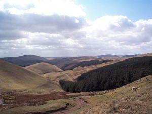 We
just could not believe our luck. The weather on Tuesday
was just bright and sunny again so we headed for the Cheviot hills
again. This time we drove to Alwinton, where there is a fell race
in August, and continued along Upper Coquet Dale to the car park
at Wedder Leap, map ref. NT 866103. From here we walked up the
lane for about 1.5km to a bridleway called The Street, on the
right hand side of the lane. It follows a spur for about 5km up
onto the border ridge. Near the border ride we saw our first group
of Cheviot wild goats with their dark chocolate brown coats and
long horns. At the ridge we kept north for a few hundred metres,
then turned east for 2km to Windy Gyle. We stopped there for lunch
and to admire the view. It was spectacular with the hills rolling
away in every direction under a brilliant blue sky. After lunch
we continued on the border ridge for 2km heading north east to
map ref. NT 871160 where we took the bridleway south for 5.5km
back to the car park at Wedder Leap. The whole route was about
16km and took us five and a half hours including our stops. We
just could not believe our luck. The weather on Tuesday
was just bright and sunny again so we headed for the Cheviot hills
again. This time we drove to Alwinton, where there is a fell race
in August, and continued along Upper Coquet Dale to the car park
at Wedder Leap, map ref. NT 866103. From here we walked up the
lane for about 1.5km to a bridleway called The Street, on the
right hand side of the lane. It follows a spur for about 5km up
onto the border ridge. Near the border ride we saw our first group
of Cheviot wild goats with their dark chocolate brown coats and
long horns. At the ridge we kept north for a few hundred metres,
then turned east for 2km to Windy Gyle. We stopped there for lunch
and to admire the view. It was spectacular with the hills rolling
away in every direction under a brilliant blue sky. After lunch
we continued on the border ridge for 2km heading north east to
map ref. NT 871160 where we took the bridleway south for 5.5km
back to the car park at Wedder Leap. The whole route was about
16km and took us five and a half hours including our stops.
The view from Windy Gyle
(top)
Wednesday 10 April 2002
A sightseeing day
 On
Wednesday we decided to give our old knees a rest and see
some of the visitor attractions of Northumberland. We drove to
Seahouses and took one of the boat trips to the Farne Islands
to see the seals and the sea birds coming to nest and hear the
story of Grace Darling's amazing rescue mission. Then we drove
to Bamburgh to see the castle and then on to Chillingham to see
the wild white cattle with a fascinating commentary by the warden
about the history and ecology of this unique herd. Finally back
to Rothbury for yet anothe great meal in the Newcastle Hotel -
by this time we had aquired a regular table. On
Wednesday we decided to give our old knees a rest and see
some of the visitor attractions of Northumberland. We drove to
Seahouses and took one of the boat trips to the Farne Islands
to see the seals and the sea birds coming to nest and hear the
story of Grace Darling's amazing rescue mission. Then we drove
to Bamburgh to see the castle and then on to Chillingham to see
the wild white cattle with a fascinating commentary by the warden
about the history and ecology of this unique herd. Finally back
to Rothbury for yet anothe great meal in the Newcastle Hotel -
by this time we had aquired a regular table.

Seals on the Farne islands
(top)
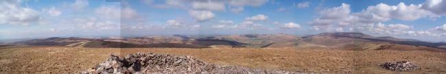
Route No.47e - Thursday 11 April 2002
Buckham's Bridge, Border Ridge,
Chew Green fort, Deels Hill circuit - 15km
Upper Coquet Dale, Cheviot Hills,
Northumberland . . .
Route map from Ordnance Survey Open Space service.
Map: OS Explorer OL16 The Cheviot Hills. 1:25000
 On
Thursday the weather was not the mediteranean blue that
we come to expect. If fact it was just an ordinary fine walking
day - the kind we would have been very happy with before the week
started! Our last chance to head for the Cheviot Hills. We returned
to the Upper Coquet Valley and parked at Buckham's Bridge, map
ref. NT 824107 We followed the permissive path along Buckham's
Walls Burn and up onto the border ridge at the mountain refuge
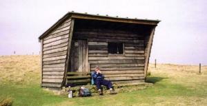
hut. There was an entry in the visitors' book at 10.00am that
morning (we arrived at about 11.00am) from a group of people who
were running the Pennine Way. On
Thursday the weather was not the mediteranean blue that
we come to expect. If fact it was just an ordinary fine walking
day - the kind we would have been very happy with before the week
started! Our last chance to head for the Cheviot Hills. We returned
to the Upper Coquet Valley and parked at Buckham's Bridge, map
ref. NT 824107 We followed the permissive path along Buckham's
Walls Burn and up onto the border ridge at the mountain refuge
hut. There was an entry in the visitors' book at 10.00am that
morning (we arrived at about 11.00am) from a group of people who
were running the Pennine Way.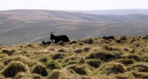 It said that they had left Edale in Derbyshire on 2 April and
were expecting to finish in Kirk Yetholm that evening, Thursday
11 April. On my reckoning that's the equivalent of about a marathon
a day for ten days - wow! Reading the entry exhausted us so we
sat on the step of the hut for some lunch. We followed the ridge
south for about 5km to the site of a roman fort at Chew Green.
There are just grassy earthworks remaining. We returned about
500m back to the Border County Ride and followed the bridleway
for about 3km back over Deels Hill to the car park at our starting
point. The whole route was about 15km and took us five hours including
our usual stops.
It said that they had left Edale in Derbyshire on 2 April and
were expecting to finish in Kirk Yetholm that evening, Thursday
11 April. On my reckoning that's the equivalent of about a marathon
a day for ten days - wow! Reading the entry exhausted us so we
sat on the step of the hut for some lunch. We followed the ridge
south for about 5km to the site of a roman fort at Chew Green.
There are just grassy earthworks remaining. We returned about
500m back to the Border County Ride and followed the bridleway
for about 3km back over Deels Hill to the car park at our starting
point. The whole route was about 15km and took us five hours including
our usual stops.

The border ridge from Deels Hill
We had planned
to have a quick look at part of Hadrian's Wall on the way home on
Friday but on Friday morning it was raining so we drove home ready
for a walk with some friends on Saturday in Bilsdale. It's the route
we checked out on 2 April before we went to Northumberland.
|

The lighthouse from which Grace Darling carried out her daring rescue
|

View north from the Pennine Way
|
|