Menu:
National Parks
The approximate route is shown by a blue line.
Use your mouse to drag the map to the area of interest and
zoom in/out using the controls on the left hand side of the map.
Please use my map to find the route on your own large scale
walking map such as the OS Explorer series at 1:25000.
If you have time if you do this walk please let me know how you get on.
That would be very helpful to me to keep my information accurate and up to date.
Please note that I provide this free service to you as a fellow walker on the
understanding that you walk
the route entirely at your own risk and that the information is not used for
any commercial purpose.
Library Route 980101 - Welburn,
Coneysthorpe, Coneysthorpe Banks Wood,
Park House, Hutton Hill circuit - 16km
Howardian Hills . . .
Map: OS Explorer 300 Howardian Hills & Malton at 1:25000
General Directions
The walk starts in Welburn at map ref. SE 721 680 near the Crown & Cushion village pub. There's usually room to park on the busy village street. About 100m east of the pub turn left down a narrow lane and continue following a bridleway across the fields for about 700m to East Moor Banks wood. Climb up through the wood and drop down along a track across a field to a farm access road at map ref. SE 722 692.
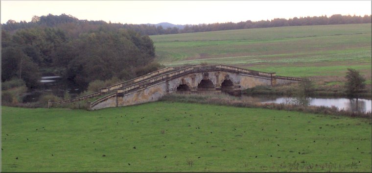
At the farm access road turn left then immediately turn right to follow a public footpath along a farm track between the fields to an ornamental bridge called New River Bridge across a landscaped water feature. Cross the bridge and follow the path across the field passing close to The Temple on the edge of the Castle Howard grounds. Continue through the wood called Horse Close Rush and follow the path along an access track to the public road on the edge of Caneysthorpe village at map ref. SE 713 712.
At the road turn left and walk along the road for about 200m then turn right to follow a service road up through Coneysthorpe village and around a chapel at the top of the village green. From the back of the chapel follow a bridleway along a farm track heading northwards out of the village. Follow the bridleway along the farm track between the fields to Coneysthorpe Banks Wood. The track & bridleway turn left and follow the bottom edge of the wood for about 100m, then the bridleway turns right and climbs diagonally up the wooded hillside to an ancient earthwork running along the ridge at the top edge of the wood.
Turn right here and follow a bridleway running along the ridge. Follow the ridge for about 3.2km to the road at map ref. SE 733 715, beyond Park House (a rural office complex). Cross the road and turn left to follow a public footpath along a track in the field opposite (now planted with trees) heading parallel to the road for about 200m then bending round to the right and dropping down a steep bank to the edge of Spring Wood at map ref. SE 734 713.
Follow the bridleway around the edge of Spring Wood, past 'The Alamo Trekking Centre' to a track called Thackadale Lane at map ref. SE 740 710. Turn right here to follow the bridleway along this lane heading southwards for about 1.6km to a 'T'-junction in the tracks at map ref. SE 741 694. Turn right here and follow the track for about 200m to High Gaterley.
Turn left here to follow a bridleway southwards along the east side of the farm and continue along this bridleway for about 1.4km to Hutton Hill farm. Take the public footpath heading westwards from Huttom Hill, through Todd Wood and then bending round to the south west following a farn track to the road at map ref. SE 727 677. At the road turn right and walk along the road (there is a footpath at the side of the road) for about 650m back into Welburn and the end of the walk.
(top of page)