Menu:
National Parks
The approximate route is shown by a blue line.
Use your mouse to drag the map to the area of interest and
zoom in/out using the controls on the left hand side of the map.
Please use my map to find the route on your own large scale
walking map such as the OS Explorer series at 1:25000.
If you have time if you do this walk please let me know how you get on.
That would be very helpful to me to keep my information accurate and up to date.
Please note that I provide this free service to you as a fellow walker on the
understanding that you walk
the route entirely at your own risk and that the information is not used for
any commercial purpose.
Library Route No.941002
Newton-on-Rawcliffe, East Brow Banks, Farwath, NYMR to Park Gate,
Newbridge, Haugh Wood, Hugh Rigg Road, West Dike Road circuit - 15km
North York Moors . . .
Map: OS Explorer OL27 North York Moors Eastern area at 1:25000
General Directions (see markers on the route map)
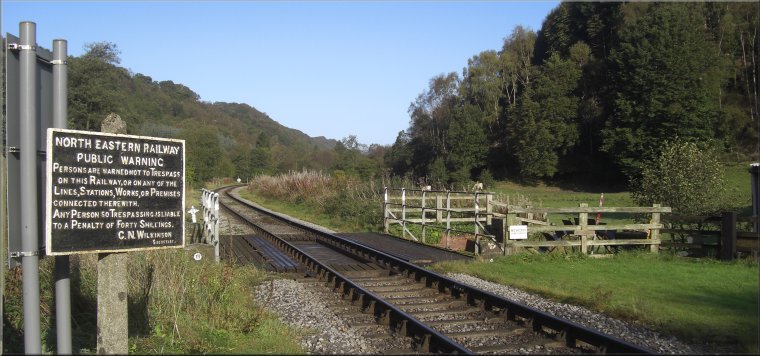
1.) Start at the duck pond on the village green at map ref. SE811905 in Newton-on-Rawcliffe. Opposite the duck pond is the White Swan pub with a public footpath down the right hand side of the pub, as you face the pub from the village green. Go along this footpath, through the caravan park at the back of the pub to a track called East Brown Road. Cross the track and take the footpath opposite zig-zagging down the hillside to join a path heading across the fields, down the valley, parallel to the North York Moors Railway (a tourist steam railway). Continue along the footpath down the valley for about 2km to a track at the level crossing over the NYMR at Farwath, map ref. SE829883.
2.) Do not cross the railway, but continue along the path through the woodland beside the railway. Follow this path for a little over 4km to a lane at Park gate and follow the lane out to the public road at Newbridge, map ref. SE802855.
3.) At the road cross over to the quarry entrance on the other side of the road. This is a working quarry with heavy lorries using this entrance so keep a lookout for the traffic. Go through the quarry yard past the offices to a gate across a track at map ref. SE801858. Go through the gate and follow the track through the woodland in the bottom of a narrow valley. The track runs through a rifle club range and there are marshals posted when the range is in use to see you safely through. Just beyond the rifle range follow the path up onto the wooded ridge in Haugh Wood. Continue along the path to the edge of the wood and a cross a large field to join a track called Haugh Rigg Road at map ref. SE802879. Follow this track for 2km to map ref. SE798899.
4.) Turn right here off the track to follow a public footpath across the fields for 1km to a track at map ref. SE808904. Follow the track heading roughly eastwards for about 350m back to the village green in Newton-in-Rawcliffe. Complete the walk by the village duck pond.
(top of page)