Menu:
National Parks
The approximate route is shown by a blue line.
Use your mouse to drag the map to the area of interest and
zoom in/out using the controls on the left hand side of the map.
Please use my map to find the route on your own large scale
walking map such as the OS Explorer series at 1:25000.
If you have time if you do this walk please let me know how you get on.
That would be very helpful to me to keep my information accurate and up to date.
Please note that I provide this free service to you as a fellow walker on the
understanding that you walk
the route entirely at your own risk and that the information is not used for
any commercial purpose.
Library Route No. 940409
Beck Hole, Murk Mire Moor,
Egton Bridge, Grosmont circuit - 15km
North York Moors . . .
Map: OS Explorer OL27 North York Moors Eastern area at 1:25000
General Directions (see markers on the route map)
1.) Start in the village of Beck Hole at map ref. NZ821022, where there is limited roadside parking. From the village street take the footpath on the north side of Eller Beck heading south west for about 150m and there turn left to cross Eller Beck on the stepping stones. After another 100m turn right to cross the footbridge over the West Beck. (note about 100m downstream the West Beck and Eller Beck join to become the Murk Esk). Once across the footbridge follow the footpath up the hillside through the woods to Thackside Farm. Follow the path around the farm and along the farm access track, out to the road at map ref. NZ813017. At the road turn right and walk along the road for about 700m to a footpath on the left just before Struntry Carr farm. Turn left off the road and follow the footpath over Murk Mire Moor for about 1.4km to another minor road at map ref. NZ800029.
2.) At map ref. NZ800029 cross the road and take the footpath opposite heading west for about 200m to a wall. Turn right to walk along the wall following a bridleway heading generally northwards to Swang Farm. The track passes through the farm yard and continues northwards for about 300m and then bends round to the left. Part way round the bend, at map ref. NZ798043, there is a path across the field heading north to join a track between trees continuing north for about 300m before bending round to the right (east). After another 250m the track continues eastwards but our route follows a footpath across the fields heading northwards down the hillside and joining a minor road at map ref. NZ801050, on the edge of Egton Bridge. At the road turn left and follow the road for 150m to a road junction in the village. Cross the junction to an access road opposite that leads to the Horseshoe Hotel. After a few metres take the footpath down some steps on the right hand side of the access road. This leads to a paved path by the River Esk and two series of stepping stones across the river as it passes round an island. Across the river go between the buildings to the road and at the road turn right to walk along the road to the end of the road at a 'T'-junction.
3.) At the 'T'-junction turn left for 20m then, at map ref. NZ804052, turn right to follow a permissive path along the old toll road, called Barnard's Road, for 2.3km to map ref. NZ823055, at the public road into Grosmont. At the road turn right and follow the road into Grosmont and over the level crossing of the North York Moors Railway.
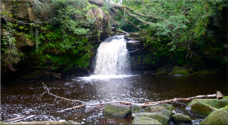
4.) From the level crossing continue along the road, up the hill for about 200m to a footpath on the right hand side of the road. Turn right off the road and go through the wooden pedestrian gate next to the footpath sign and follow the footpath through the woods to an access road at map ref. NZ829049. Turn left at the access road and walk along it climbing up through the woods for about 150m. Just through a field gate across the access road turn right and follow the footpath along the field edge and then through the woods (wild flowers especially bluebells) for 1.2km to the access road at Green End, map ref. NZ825035. At the access road turn left for 50m then turn right off the access road and follow the path trough Liberty Hall farm and across the fields to the road next to Hollin Garth Farm, map ref. NZ824029. At the road turn right and follow the road back into Beck Hole. The walk can be ended here but it's worth making a short detour of about 400m there and 400m back to follow the footpath on the left hand side of the road in Beck Hole along the bank of Eller Beck to the foot of Thomason Foss waterfall to complete the route.
(top of page)