Menu:
National Parks
The approximate route is shown by a blue line.
Use your mouse to drag the map to the area of interest and
zoom in/out using the controls on the left hand side of the map.
Please use my map to find the route on your own large scale
walking map such as the OS Explorer series at 1:25000.
If you have time if you do this walk please let me know how you get on.
That would be very helpful to me to keep my information accurate and up to date.
Please note that I provide this free service to you as a fellow walker on the
understanding that you walk
the route entirely at your own risk and that the information is not used for
any commercial purpose.
Library Route No. 930903
Gaisgill, Knott, Hare Shaw, Uldale Head,
Docker Knott, Wind Scarth, Simon's Seat,
Middleton, Langdale circuit - 16km
Howgill Fells . . .
Map: OS Explorer OL19 Howgill Fells and Upper Eden Valley at 1:25000
General Directions (see markers on the route map)
1.) Start at map ref. NY637037 just before the end of the public road leading to Intake Farm, about 1km south of the tiny village of Gaisgill, off the A685 about 2km east of Tebay (M6 services). There's room to park off the road on the coarse grass moorland. Follow the track climbing up the open fellside for about 1km to the point where the track stops climbing and begins to contour round Weather Hill. Here, map ref. NY632035, where there is a public footpath heading off to the right, leave the track and head south west up to the top of Weather Hill. Continue southwards along the ridge of the fell for about 1km to the top of Knott.
2.) From Knott continue climbing along the ridge of the fell to the cairn at the top of Hare Shaw (472m AOD), map ref. NY627013. Continue about 400m beyond the top of Hare Shaw and then turn left to cross Archer Moss on to the saddle between Rispa Pike and Uldale Head. From this saddle turn right and climb along the ridge of the fell for about 600m to the top of Uldale Head (532m AOD), map ref. NY640000.
3.) From the top of Uldale Head follow the ridge of the fell down to Blakethwaite Bottom and the Blakethwaite Stone, an old boundary marker between Westmorland and the North Riding of Yorkshire. From the Blakethwaite Stone head north east for about 450m to the ridge of the fell between Hand Lake and Docker Knott. At the ridge turn right to follow the ridge up to the top of Docker Knott.
4.) From the top of Docker Knott head generally southwards following the ridge of the fell for a little over 1km to Wind Scarth at map ref. SD656989. From Wind Scarth turn left to head generally northwards along the ridge of the fell for about 1km across a saddle in the ridge and up steeply to the top of Simon's Seat at map ref. SD660999.
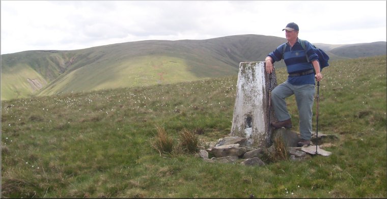
5.) From the top of Simon's Seat head north west down a ridge of the fell for about 800m and then northwards for another 700m to the trig point on the top of Middleton at map ref. NY652012. From the top of Middleton follow the end of the ridge down for about 1.3km to the old sheep fold by the confluence of Churngill Beck and Uldale Beck at map ref. NY646023.
6.) From the old sheepfold by the beck head north west straight up the steep fellside with the intake wall about 100m away to the right.After about 200m cross a path that heads northwards around the intake wall, and continue down the fellside to cross Eller Gill beck at the corner of the intake wall at map ref.NY636027. Once across the beck follow the wall westwards up the fellside for about 250m where the wall turns sharp right. Continue westwards up the fellside for another 100n to join the track from the start of the route. At the track turn right to follow the track northwards for about 2km back to the start of the walk near Intake Farm.
(top of page)